Stanford Area Trails
walk/run/bike/horse

Official Parks and Recreation
Staff-Recommended Trail Routes

The Santa Clara County Department of Parks and Recreation has released its recommendations for the two trails in the Dish area. They look good. They're based on the "optimal routes" we've discussed previously, with a few adjustments. County Parks and Recreation staff recommends routes S1-E or S1-B, and C1-D, on the map below.

Both S1-E and S1-B are good recreational trails. S1-B is nicer, and goes through the main Dish area. S1-E hugs the outer perimeter of Stanford land, but has some very pretty spots. Both go under Interstate 280 via the service road tunnel and connect to the Arastadero Preserve without any road crossings.

Trail C1-D goes alongside (not through) the Stanford Golf Course and connects to the Portola Valley trail system, with no road crossings other than Junipero Serra at Campus Drive, which has a traffic light. It doesn't go through the Felt Lake area.

These routes still have to be negotiated with Stanford, but the Supervisors have considerable negotiating leverage.

The Board is only accepting the staff report at this meeting, not making a decision, but we'd like people to show up in support of these routes.

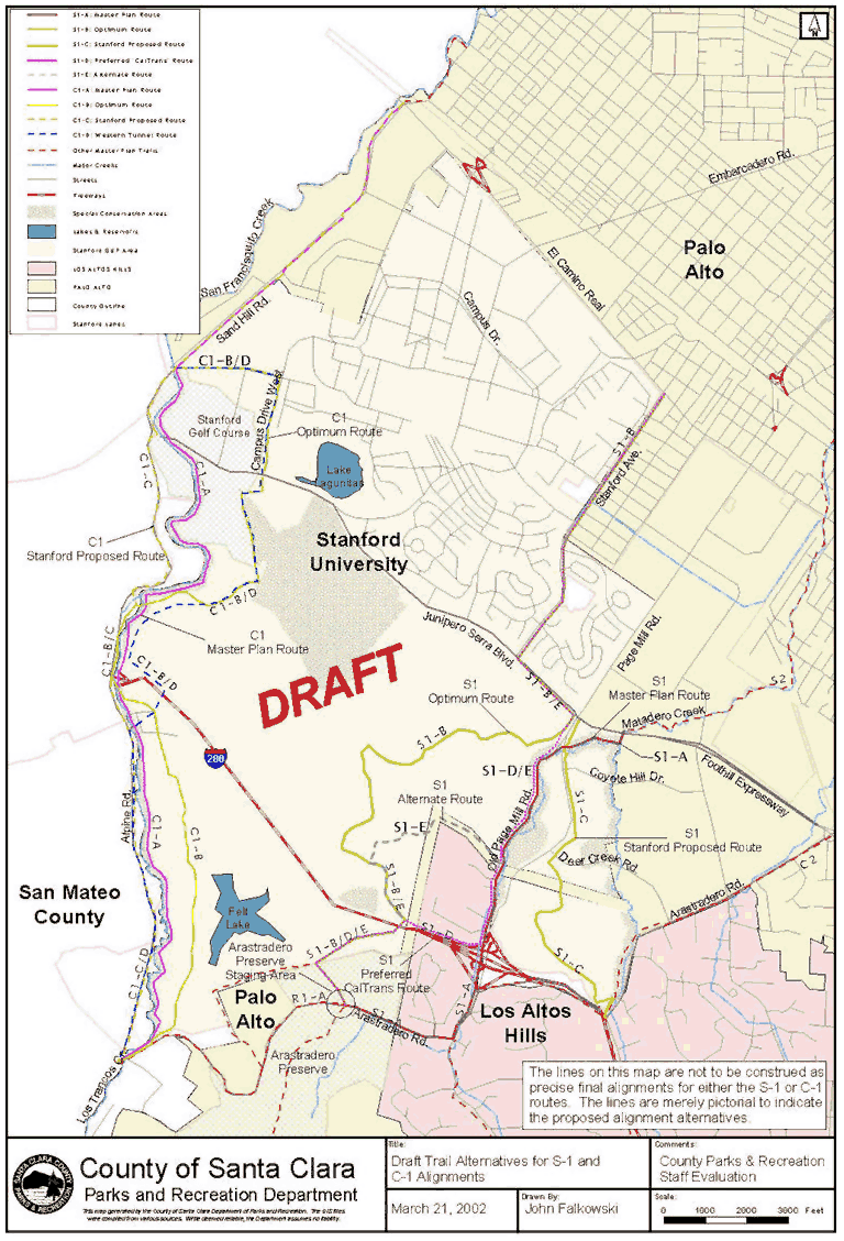
Summary of the staff recommendations:

"In County Staff's evaluation of the five S-1 trail alternatives, the S1-E route (perimeter trail route along Stanford Foothills/ Los Altos Hills border) offers the best potential for further consideration. .... Taking into consideration the property owner's opposition to this route, County Staff evaluated the S1-B route (Optimum Recreational Experience Route) and found the following outcome: (a) LOW environmental impacts; (b) POSSIBLE regulatory issues; (c) HIGH impacts to private property interests; (d) MEDIUM to HIGH recreation value; and (e) LOW risk to public safety (See Attachment G). The S1-B route also offers a technically feasible route for consideration, if the property owner were agreeable.

In County Staff's evaluation of the five C-1 trail alternatives, the C1-D route (Modified Route with Combination of C1-B and C1-C) offers the best potential for further consideration."


Public Documents (directly from the County of Santa Clara web site)


Agenda Item 51 (Staff report to the Board from Parks and Recreation)

Supporting documents

Board Agenda for April 30. 2002
Attachment C: March 12, 2002 Letter from Stanford , RE: Steps for Obtaining CalTrans Permission to Build and Use a Trail on the I-280 Right-of-Way(Miscellaneous)
Attachment B: January 28, 2002 Letter from CalTrans, RE: S-1 Alternative Pedestrian Pathway Proposed in CalTrans Right-of-Way(Miscellaneous)
Attachment H: Summary of Evaluations for C-1 Trail Alternatives(Miscellaneous)
Attachment I: Revised Trail Alternatives Map(Miscellaneous)
Attachment A: January 14, 2002 Letter from BKF, RE: S-1 Path Study in the CalTrans Right-of-Way(Miscellaneous)
Attachment G: Summary of Evaluations for C-1 Trail Alternatives(Miscellaneous)
Attachment F: Evaluation of all C-1 Trail Alternatives(Miscellaneous)
Attachment E: Evaluation of all S-1 Trail Alternatives(Miscellaneous)
Attachment D: Matrix of Criteria and Methodology(Miscellaneous)


This site is operated by a group of Stanford-area people, many of whom are Stanford alumni.
It is not an official site of Stanford University.
Last update April 25, 2002.