| Stanford
Area Trails walk/run/bike/horse |
San Francisquito / Los Trancos Trail Link (C-1)Executive summaryStanford is required by its General Use Permit to dedicate easements for and build out sections of two county trails within one year of its signing of the GUP. Trail C1, as mapped, runs from Sand Hill at the Palo Alto city line to the Arastadero Preserve, generally following San Francisquito Creek through the golf course and the Felt Lake area. The mapped routes are considered general and are subject to adjustment. The RequirementFrom the final Conditions of Approval of Stanford's
2000 General Use Permit: from the County of Santa Clara: 2. Stanford shall dedicate easements for, develop, and maintain the portions of the two trail alignments which cross Stanford lands shown in the 1995 Santa Clara Countywide Trails Master Plan (Routes S1 and C1), according to the following timeline: a. In consultation with the County Parks and Recreation Department, Stanford shall identify trail easements and complete Agreements for Trail Easements within one year of GUP approval. For purposes of this condition, the term easement includes any other equally enforceable mechanism acceptable to the County Board of Supervisors. The trail alignments in the Countywide Trails Master Plan
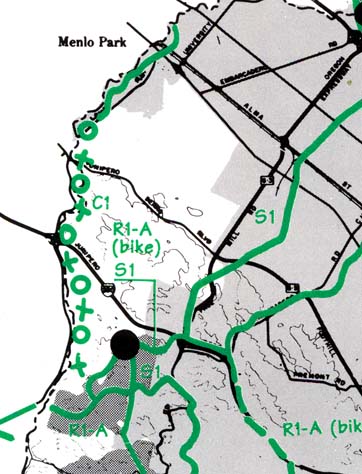
Trail C-1 is shown on the Countywide Trails Master Plan as paralleling San Francisquito Creek on the east (Santa Clara County) side of the creek. (The creek is the county line.) Trail C-1 is mapped with the X-O-X-O notation indicating a trail on private property from the Palo Alto city line to Arastadero Road in Portola Valley. This entire stretch of land is owned by Stanford from the Palo Alto line on Sand Hill Road to the Arastadero Preserve of the City of Palo Alto. So this is the section of trail C-1 for which Stanford has an obligation. From table D-1 of the Countywide Trail Master Plan:
Stanford / County Parks initial proposalJane Mark of Santa Clara County's Department of Parks and Recreation, with the assistance of Charles Carter of Stanford's planning office, has come up with the following "planning matrix" for this trail.
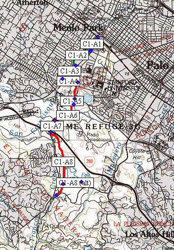
Our proposalThe "matrix" above covers the segments north of Junipero Serra; it does not continue to Arastadero Road as required. So we have updated the "matrix" to cover that omission: (Click on any segment below for a photo tour of the segment.)
Route description and notes
The trail alignment shown by the trail plan runs through the Stanford Golf Course. This is the main problem. Were it not for the golf course, the trail routing would be clear - it would run along the east bank of San Francisquito Creek. This is the baseline route. There is general agreement amongst all parties (trail users, golfers, environmentalists, and Stanford) that going through the golf course is undesirable, for reasons of safety, environmental impact on the creek and its wildlife, and impact on the golf course itself. It is not impossible to run a trail very close to a golf course. Pebble Beach has trails along parts of its golf courses. But it would be better to go around if at all possible. Immediately to the east of the golf course is undeveloped open space owned by Stanford. There are no serious physical or environmental obstacles to a routing east of the golf course. Stanford has previously objected to this routing on the grounds that it might interfere with future development of this open space. (Ref: conversation with Charles Carter, Stanford planning). This is the only significant problem with that route. Immediately to the west of the creek is San Mateo County. There is a significant legal question as to whether Stanford can legally fulfill its obligations to Santa Clara County with a project in another county. The area immediately west of the creek north of I-280 contains residential developments, running up to the creek bank in some instances. The area west of the creek is generally suburban; east of the creek, in Santa Clara County, is generally rural or open space. There is an existing sidewalk along Alpine Road in San Mateo county. It was once a recreational trail, developed with Federal funds in the 1960s. But with increasing urbanization and widening of Alpine Road, it has been reduced to a sidewalk. Some sections are substandard as a sidewalk, let alone a trail. Our general position on this trail is as follows: These trail segments must be entirely within Santa Clara County. The trail should start at Sand Hill in Palo Alto where Stanford's existing Searsville Path connects, be reachable from the Stanford Equestrian Center, continue across the campus using existing pathways to Junipero Serra and Campus Drive, continue towards the golf course, and run outside and east of the golf course. It should connect to the existing San Mateo County trail at the Piers Lane bridge. At this time, we have no detailed position on a preferred route for the section of this trail through the Felt Lake area, except that it must connect to the DeAnza Trail or the Arastadero Preserve trail system. This trail should meet Trail Standard G-2 (multi-use, paved and unpaved) or G-3 (multi-use, unpaved). The trail must have no gaps between the endpoints. Stanford positionsIn 1995, Stanford was asked by the County to comment on the Countywide Trail Master Plan. (Ref Letter K, September 15, 1995, in "Final Supplemental Environmental Impact Report, Countywide Trail Master Plan Update".) Stanford's comment on trail routing at that time was as follows:"We would not want to provide additional pathways through the existing leaseholds in the Research Park (Trail S1 between El Camino Real and Junipero Serra Boulevard). We would also need to prevent public access to other leaseholds on Stanford lands. The open space west of Junipero Serra Boulevard are agricultural leases and public access would need to be prevented. It would be possible to consider easements at the boundaries of the leases if they were fenced to prevent public access. This could affect portions of trails S1, C1, and C2." The "leaseholds in the research park" issue reflects that Trail S-1, if run along Matadero Creek as in the plan, would run through the Research Park from El Camino to Junipero Serra. Connecting to the existing trail along Stanford Avenue is an alternative which would avoid this objection expressed by Stanford. Stanford also pointed out a minor inconsistency in the map:
Stanford also made a general policy statement on trails:
We have informally heard from Charles Carter of Stanford Planning that Stanford would like to avoid building trail C1, arguing that the Alpine Road trail in San Mateo County is sufficient. This would clearly be noncompliance with the General Use Permit. Parties involvedSanta Clara County Parks and Recreation is the lead agency on this effort. Jane Mark there is currently staffing it. On the Stanford side, Charles Carter in Stanford's planning office is currently staffing the issue. Neighboring jurisdictions (definitely Palo Alto, Portola Valley, and Los Altos Hills, and possibly San Mateo County and Menlo Park) have some involvement because trail connections to their trail systems are involved. Palo Alto's lead is Greg Betts, the Open Space director. Portola Valley's lead is Mary Hufty, chair of the Portola Valley Trail Commission. Various community groups are involved as well, including the College Terrace Association, the Committee for Green Foothills, and a number of trail-using organizations listed separately. At the political level, there has been some involvement by Supervisor Liz Kniss' office, and former Supervisor (now Assemblyman) Joe Simitian was instrumental in getting this requirement into the GUP. Prepared by John Nagle / 8 July 2001 |
||||||||||||||||||||||||||||||||||||||||||||||||||||||||||||||||||||||||||||||||||||||||||||||||||||||||||||||||||||||||||||||||||||||||||||||||||||||||||||||||||||||||||||||||||||||||||||||||||||||||||||||||||||||||||||||||||||||||||||||||||||||||||||||||||||||||||||||||||||||||||||||||||